COD Tutorial: How to consume COD live services
Introduction
ITOS is serving map and feature services of OCHA’s Common Operational Datasets, specifically, populated places and administrative boundaries. These services are designed to work as base layers in cartographic products and applications. The services focus on providing easy access to names and pcodes.
For those who are familiar with how to consume services, the links in this REST catalog will allow you to consume the data in your platform of choice:
https://codgis.itos.uga.edu/arcgis/rest/services/COD_External. Links to live services are also available on many HDX country COD pages.
The COD services are developed and deployed by country. Each country has:
Map Services intended as a simple base map for the country showing administrative units and their name, and populated places and their name symbolized by rank. The map services have ESRI Map, ESRI Feature, KML and WMS endpoints. The country map services have features that turn off an on at different scales. This service is primarily used for consuming basemaps in ESRI, Google Earth (as image overlays), and OGC clients, and for data processing in ESRI clients.
Feature Services stream features from the administrative units and populated places COD data to the client. These feature services allow users to manipulate data in their desktop as if it were locally loaded: they can change symbology, perform geoprocessing tasks, and manipulate the base layer maps. Be very careful - the feature and WFS services should not be used for subset or data extraction. For cartographic reasons, the WFS and ESRI feature services have definition queries that restrict some of the data records (removes them from the service). If users want a copy of the data, they can get them from the WAF or the pcode service (using the API to extract features against the map service as geoJson), download them from Dropbox or HDX. If there is a use case for needing all datasets via a feature service let ITOS know and they will enable one on a region by region basis.
The feature services have ESRI Map, ESRI Feature, KML, and OGC WMS and WFS endpoints. These services are also known as ‘pcode’ services. The services provide pcode labels intended to be used in conjunction with the country map service described in (1) above. The pcode labels are either off or on and do not appear and disappear at different scales. This service is primarily used for feature access via WFS, KMZ (via network overlays), and pcode labels for either OGC or ESRI clients.
There is one map service and one feature service for each language in the country’s database, and one pcode service per country. For example, for the Iraqi services, there is one Map Service and one Feature service in English, one Map Service and one Feature service in Arabic, and one MapService (with a WFS endpoint) for pcodes.
When you use either the ESRI feature service or the WFS, you will get all data for the country, including data that may not be in the base map. For example, in Colombia, we have an urban areas feature class that isn’t in the basemap. You have access to it via ESRI Feature and WFS services. This table gives a snapshot of the services and their intended use:
Minimum of 3, and up to 5 services per country (with multiple endpoints).
Service Type | Examples | Endpoints | Description |
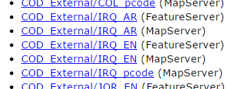
FeatureServer | COD_External/IRQ_AR(FeatureServer) COD_External/IRQ_EN(FeatureServer) | ESRI Map, ESRI Feature | Intended as base map and feature extraction for ESRI clients (available in 1-2 languages). |
MapServer | COD_External/IRQ_AR(MapServer) COD_External/IRQ_EN(MapServer) | ESRI Map, WMS, KML Image overlay (recommended) | Intended as the base map for ESRI or OGC clients (available in 1-2 languages). Name labels only |
MapServer | COD_External/IRQ_pcode(MapServer) | ESRI Map, WMS, WFS, KML Image overlay (not recommended), KML Network Link (recommended) | Intended as a labeling layer for PCODES for all clients, and feature extraction for OGC clients. All countries get a single pcode service |
Instructions for
Non-developers
- ESRI Clients
- ArcGIS Desktop (9.x and 10.x)
- ArcGIS Pro
- AGSOnline
- Google Earth
- Browsers
- Open source clients
- How to find WFS/WMS endpoints
- QGIS
- UDig
Analytics Packages
- Tableau
- Qlick
Developers
- The Rest Catalog and ESRI API
- OpenLayers and Drupal
- CKAN
- EsriJson
- HTML
- Leaflet
- Shapley
- Mapbox (JavaScript)
More information about ITOS and COD Services: ITOS and CODs
Link to google doc: How to consume COD live services