...
The goal is to create a shapefile with individual line features between nodes and left and right polygon identifiers. (Polygon shapefile exterior features have their left polygon identified as '-1'.) This can be performed with ArcGIS 'Advanced' license of or the registered version of ET GeoWizards.
...
| Administrative levels in boundary polygon shapefile | Required calculations |
|---|---|
| Administrative levels 0 and 1 | polyline shapefile 'LEFT_A'0 = polygon shapefile 'ADM0_PCODE' |
| Administrative levels 0, 1, and 2 | polyline shapefile 'LEFT_A0' = polygon shapefile 'ADM0_PCODE' polyline shapefile 'LEFT_A1' = polygon shapefile 'ADM1_PCODE' |
| Administrative levels 0, 1, 2, and 3 | polyline shapefile 'LEFT_A0' = polygon shapefile 'ADM0_PCODE' polyline shapefile 'LEFT_A1' = polygon shapefile 'ADM1_PCODE' polyline shapefile 'LEFT_A2' = polygon shapefile 'ADM2_PCODE' |
| Tip |
|---|
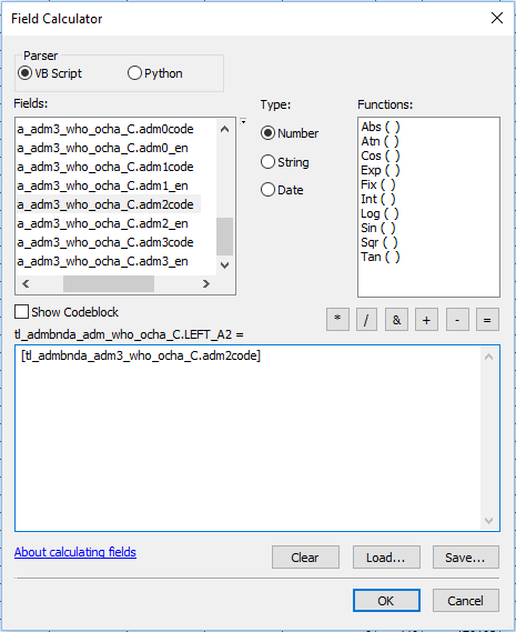
| Usually when the Field Calculator is re-opened during an editing session it maintains the previous calculation expression ("[tl_admbnda_adm3_who_ocha_C.adm2code]" in the above example. Therefore is is usually only necessary to edit the administrative level number to prepare the next calculation. |
- Close the attribute table, remove the join, and establish a new join basing on 'RIGHT_FID'. Anticipate all records matching.
- This time there should be no need to make a definition query, as there should be no null values.
- Open the output polyline shapefile attribute table.
- Use the Field Calculator to calculate all the RIGHT_Ax values (for the RIGHT_Ax files recently added to the polyline shapefile ) equal to the corresponding administrative levels of the polygon shapefile.
- Remove the join.
...