Table of Contents
...
This process generates a lines shapefile with one line ('arc') along each border between nodes, and identifies the left and right polygon Feature Identifiers (FIDs) for each line feature. By convention, the outer polygon boundary is always stored in a clockwise direction so while every line will have a polygon on its right; lines on the exterior of the input shapefile will have no polygon on their left. The attribute table indicates these cases with the LEFT_FID = -1.
The remaining processes are completed in ArcGIS Desktop or Pro, regardless of the software environment used above. (Illustrations are for ArcGIS Pro.)
...
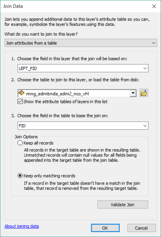
- Right-click the polyline shapefile used for the lines shapefile creation, then select "Joins & Relates" > "Add join..." and provide the Join Data as follows:
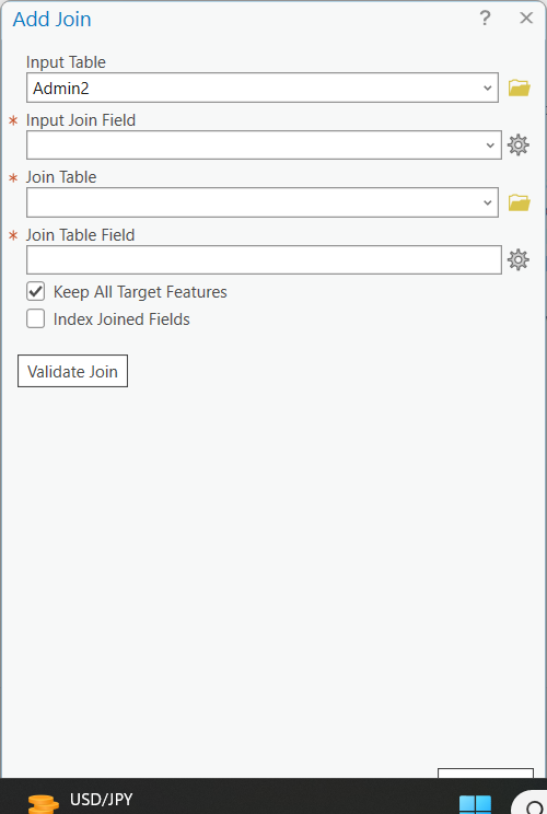
- Input table = lines shapefile
- Input Join Field = LEFT_FID
- Join table = polygons shapefile
- Join table field = FID
Although not essential, it may be useful to click "Validate Join".
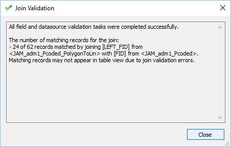
Typical validation message:
Start Time: 05 October 2023 14:55:43
Checking for invalid characters...
Checking workspaces...
The join is being done between different workspaces. Performance is lost due to the join being done client side.
Checking for field indexes...
The join field LEFT_FID in the table Lines layers.col_adml_ALL_v01.shp is not indexed. To improve performance, we recommend that an index be created.
Checking for OIDs...
Checking for join cardinality (1:1 or 1:m joins)...
A one - to - one join has matched 4291 records.
The input table has 4493 and the join table has 1122 records.
Succeeded at 05 October 2023 14:56:49 (Elapsed Time: 1 minutes 5 seconds)
...
Do not expect all records to match - because the ‘left’ side of all exterior lines will have no neighbouring polygon. Do not worry if you receive a “Field names that match reserved words should not be used in database schema and can cause the join to fail. The following fields match reserved words….” message. Close the 'Join Validation' dialogue box after inspecting the result.
 ’
’
- Click ‘OK’
- Open the output polyline shapefile attribute table
- Use the Field Calculator to calculate all the LEFT_An values (for the LEFT_An files recently added to the polyline shapefile) equal to the corresponding administrative levels of the polygon shapefile. (ArcGIS may require you to begin an edit session.)
...
- Close the attribute table, remove the join, and establish a new join basing on 'RIGHT_FID'. Anticipate all records matching.This time there should be no need to make a definition query, as there should be no null values.
- Open the output polyline shapefile attribute table.
- Use the Field Calculator to calculate all the RIGHT_An values (for the RIGHT_An files recently added to the polyline shapefile ) equal to the corresponding administrative levels of the polygon shapefile.
- Remove the join.
...
- Verify that admLevel was set to 0 for all features when the field was created. If this is indeed the case then it is only necessary to adjust admLevel to 99 for shoreline features according to the SHORELINE TREATMENT section below. Higher administrative level boundaries will be re-coded later.
SHORELINE TREATMENT
- At this stage all features will have the default admLevel = 0, indicating international boundaries. If there are shorelines, they must be coded to 99. Jump to the HIGHER ADMINISTRATIVE LEVELS section below if there are no shorelines.
- Open an editing session for the line shapefile.
- If the lines layer is complex it may be useful to use a defininition query (described below) to filter only the 'internatinoal' boundaries. ADD EXPLANATION HERE
- Manually select line segments that represent shorelines (splitting line segments where an international border meets the water). It may be useful to add a world country layer or neighbouring country layers.
...