...
The goal is to create a shapefile with individual line features between nodes and left and right polygon identifiers. (Polygon shapefile exterior features have their left polygon identified as '-1'.) This process is discussed below for four software environmentscan be performed with ArcGIS 'Advanced' license of the registered version of ET GeoWizards.
| Software environment | Remarks | Methodology |
|---|---|---|
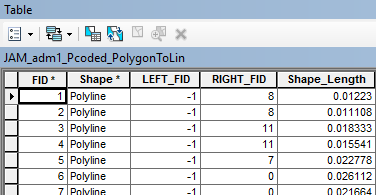
| ArcGIS Requires ('Advanced' license) | Run the ArcGIS ‘Polygon to Polyline’ tool (Toolbox > Data Management Tools > Features > Polygon To Line) with: "Input Features" = (input polygon shapefile); "Output Feature Class" = (as desired); "Identify and store polygon neighboring information (optional)" selected; and all environment settings set as default. Sample input parameters: Sample output: | |
| ET GeoWizard free version | Limited to 100 features | |
| ET GeoWizards paid version | Unlimited polygon capability | Same as 'ET GeoWizards' free version process described above |
| QGIS | Not suitable. It appears that the QGIS plugin makes polylines around the whole, rather than distinct lines between nodes. If any user has more information, please contact ocha-fis-data@un.orgGeoWizards registered version | Run the Polygons TO Polylines Advanced tool
Select the 'OBJECTID' field for the 'Link field'. Do not select 'Export points'. |


The remaining processes are completed in ArcGIS, regardless of the software environment used above.
...